


Hull Coastline Masterplan
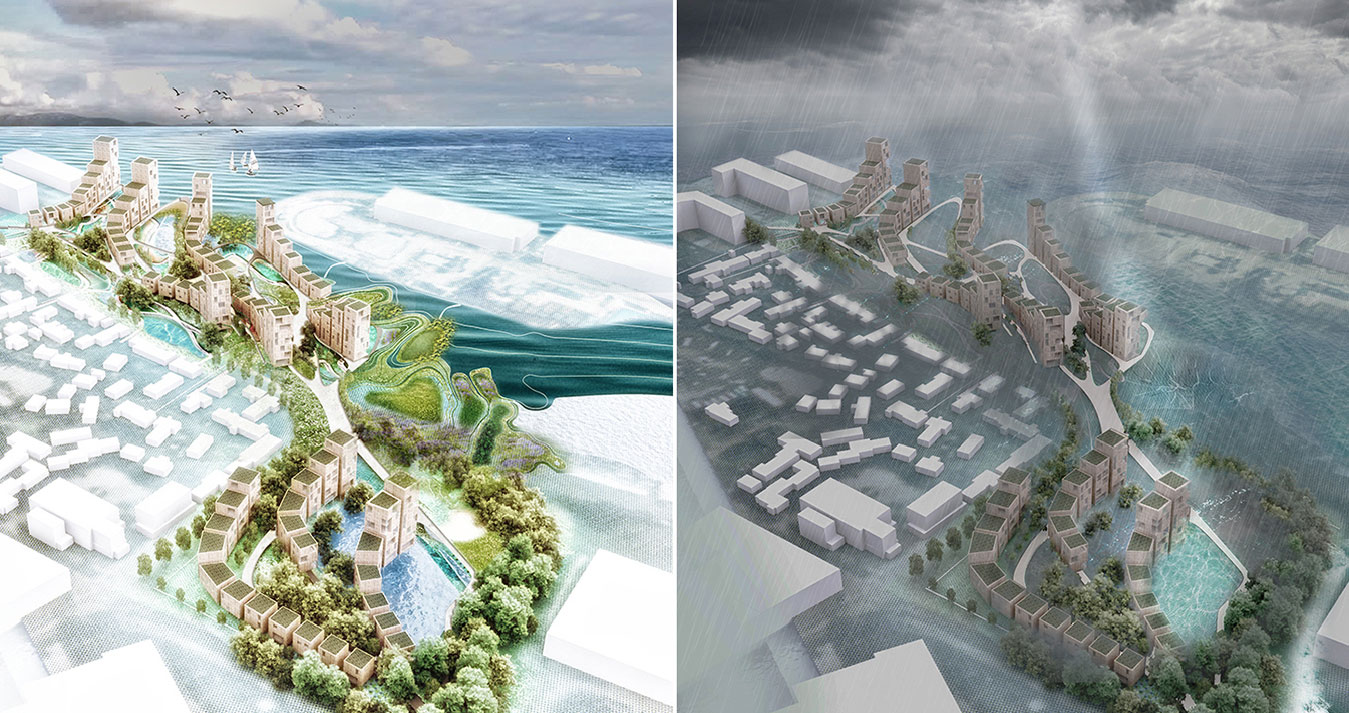
The proposal for Living with Water for the city of Hull aims to make the site more resilient to flooding which means to put in place socio-ecological systems that are able to (1) absorb stresses coming from flooding and maintain function and (2) adapt, reorganize, and evolve into more desirable configurations that improve the sustainability of the system, leaving it better prepared for future flooding impacts. With its large complex of historic industrial docks next to the Humber estuary, the project site: Kingston upon Hull is also one of the large communities predicted to be largely sunk in every high tide in the next 80 years. This condition requires to radically reconsidering the future of Hull and the systems that will define the city; requiring ecology led urban design as a substitute of infrastructure led urban design.
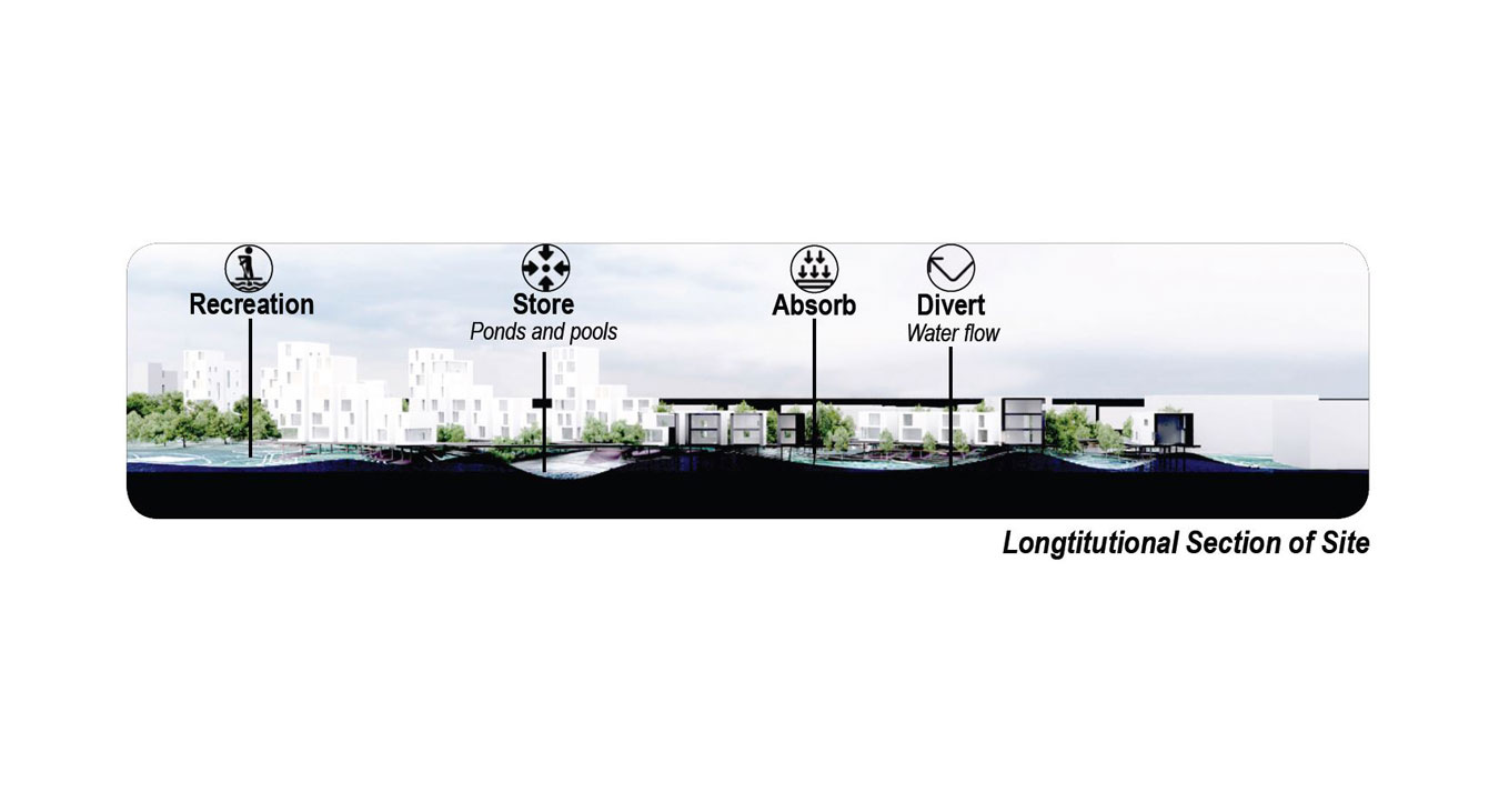
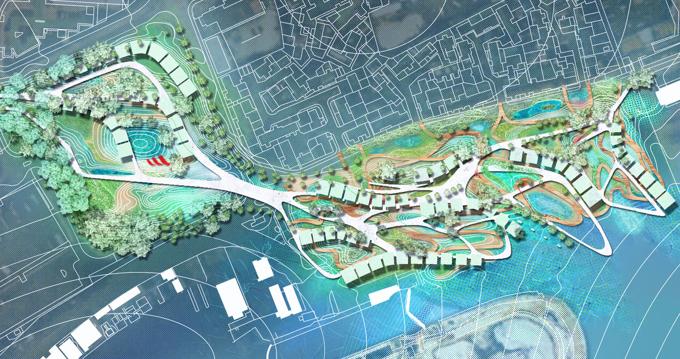
This new ecology is constituted by layered flood protection systems; some provide long term protection from rising sea levels and others short term systems that create social, environmental, and economic benefits for the people of Hull. The spaces are activated with water based on the principles of “natural flood management” which consist of using green spaces to hold then slowly release water following an extreme event. This new ecology is designed following four principles: (1) Activate the intertidal habitat, (2) Managed retreat or managed realignment: a coastal management strategy that allows the shoreline to move inland, instead of attempting to hold the line with structural engineering. (3) Store by allocating water ponds and reservoirs. (4) Divert by establishing flood pathways.
The proposal includes elevated waterfront parks and an elevated network system above the expected high-tide level in 2100. A system of floodable pathways improves the connection between the existing neighbourhood and the shoreline. Site amenities have the potential to enhance the public realm, social equity and economic opportunity. The soft dike cluster is an absorptive undulated terrain designed to allow tidal waves gently flood in and be partly absorbed, while nurturing the productive tidal ecosystem where recreational spaces are installed within.
- [status] Ideas
- [location] Europe, Hull
- [program] Masterplanning
- [date] 2019
- [area] 5000m2
Hull Coastline Masterplan
The proposal for Living with Water for the city of Hull aims to make the site more resilient to flooding which means to put in place socio-ecological systems that are able to (1) absorb stresses coming from flooding and maintain function and (2) adapt, reorganize, and evolve into more desirable configurations that improve the sustainability of the system, leaving it better prepared for future flooding impacts. With its large complex of historic industrial docks next to the Humber estuary, the project site: Kingston upon Hull is also one of the large communities predicted to be largely sunk in every high tide in the next 80 years. This condition requires to radically reconsidering the future of Hull and the systems that will define the city; requiring ecology led urban design as a substitute of infrastructure led urban design.
This new ecology is constituted by layered flood protection systems; some provide long term protection from rising sea levels and others short term systems that create social, environmental, and economic benefits for the people of Hull. The spaces are activated with water based on the principles of “natural flood management” which consist of using green spaces to hold then slowly release water following an extreme event. This new ecology is designed following four principles: (1) Activate the intertidal habitat, (2) Managed retreat or managed realignment: a coastal management strategy that allows the shoreline to move inland, instead of attempting to hold the line with structural engineering. (3) Store by allocating water ponds and reservoirs. (4) Divert by establishing flood pathways.
The proposal includes elevated waterfront parks and an elevated network system above the expected high-tide level in 2100. A system of floodable pathways improves the connection between the existing neighbourhood and the shoreline. Site amenities have the potential to enhance the public realm, social equity and economic opportunity. The soft dike cluster is an absorptive undulated terrain designed to allow tidal waves gently flood in and be partly absorbed, while nurturing the productive tidal ecosystem where recreational spaces are installed within.